
Aviation Glossary
| ADF |
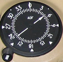 Automatic Direction Finder.
If tuned to the frequency of a radio transmitter it will point towards that transmitter.
Normally it would be tuned to a navigational beacon, or
NDB, but it can also be tuned to a public
broadcasting station in the AM frequency band (200-1655kHz). For example, 2RN (Radio National) is
702kHz and is located south-west of Bankstown. This should be used with caution as some transmitters
are simply repeater stations, so you may be heading towards one of those instead of the main tower.
Automatic Direction Finder.
If tuned to the frequency of a radio transmitter it will point towards that transmitter.
Normally it would be tuned to a navigational beacon, or
NDB, but it can also be tuned to a public
broadcasting station in the AM frequency band (200-1655kHz). For example, 2RN (Radio National) is
702kHz and is located south-west of Bankstown. This should be used with caution as some transmitters
are simply repeater stations, so you may be heading towards one of those instead of the main tower.The ADF can also be used to receive the ATIS. See lesson 27 for an example of this secondary usage. Of Curtis Aviation's Citabrias, WKM has an ADF; RRW and MWY don't. See Cessna 172 cockpit for an example fitted to a Cessna 172. |
| AFRU |
Aerodrome
Frequency
Response
Unit A device installed at many non-towered aerodromes to assist pilots' awarenesss of an incorrectly-selected VHF frequency. More detail in lesson 49 - first solo flight post-GFPT. |
| AGL | Above Ground Level (as opposed to AMSL). Heights in the regulations are usually quoted in feet AGL, eg normal circuit height (and minimum height above built-up areas) is 1000' AGL; minimum height above ground is 500' AGL. (Legal aside: height is measured above the ground, or any object on it, within a radius of 600 metres from a point vertically below the aircraft.) |
| AH | Artificial Horizon. More commonly known now as Attitude Indicator. |
| AI |
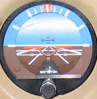 Attitude Indicator. The prime source of attitude information
in instrument flight. The mechanism is a gyro, driven by suction.
Attitude Indicator. The prime source of attitude information
in instrument flight. The mechanism is a gyro, driven by suction.
 The face is marked with bank
angles at 0°, 10°, 20°, 30°, 60° and 90°,
and pitch angles at -20°, -10°, 0°, +5°, +10° and +15°.
The face is marked with bank
angles at 0°, 10°, 20°, 30°, 60° and 90°,
and pitch angles at -20°, -10°, 0°, +5°, +10° and +15°.When flying on instruments, the AI should be checked every few seconds. See Cessna 172 cockpit. |
| ALA | Authorised Landing Area. An airstrip that doesn't meet the requirements of an airport. Local examples: The Oaks, Wedderburn, Yerranderie and the narrow gravel strip by the pipeline to Prospect. |
| ALAP | Work cycle in flight:
Attitude
Note that three of the four items require the pilot's focus to be outside the cockpit. Introduced in lesson 3 - Straight and Level Flight.
Reintroduced in lesson 28 - Advanced turning as a constant reminder during climbs and steep turns.
Lookout Attitude Performance |
| ALP | Work cycle on final approach:
Aim point
Introduced in lesson 9 - Circuits.
Line Performance |
| Altimeter |
 An instrument used to measure pressure, which is displayed as height above a
fixed level, usually Mean Sea Level.
An instrument used to measure pressure, which is displayed as height above a
fixed level, usually Mean Sea Level.
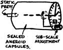 The mechanism is a sealed aneroid capsule inside a container open to the outside
pressure via a static vent. It reads like a clock, with markings every 20 and
100 feet ('minute' hand) or 200 and 1000 feet ('hour' hand). A subscale is set to
local or area QNH so that all
aircraft in the area are displaying consistent heights.
The mechanism is a sealed aneroid capsule inside a container open to the outside
pressure via a static vent. It reads like a clock, with markings every 20 and
100 feet ('minute' hand) or 200 and 1000 feet ('hour' hand). A subscale is set to
local or area QNH so that all
aircraft in the area are displaying consistent heights.
See Wikipedia - Altimeter. |
| AMSL | Above Mean Sea Level (as opposed to AGL). Circuit heights for individual aerodromes are in feet AMSL, eg Camden is 1300' AMSL; incoming traffic should be at 1800' AMSL. |
| ANC | A reminder by instructors to keen students that the priorities when flying a plane are Aviate, Navigate, Communicate. So, for example, radio calls should not interfere with keeping the plane flying smoothly. Also relevant in an emergency, eg if the engine fails, establish a best-rate glide before making a mayday call. |
| AoA | Angle of Attack. The angle between the chord line of the wings and the relative airflow. Flying at a high angle of attack risks bringing on a stall. |
| APST |
Procedure for levelling out after a climb:
Attitude
Lower the nose first and allow the plane to accelerate to cruising speed before reducing the power. This way you won't experience the sinking feeling that results if you reduce the power first. Introduced in lesson 4 - Climbing and Descending.
Power Speed Trim |
| ARN | Aviation Reference Number. Issued to each prospective pilot by CASA. |
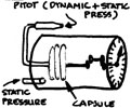
| ASI |
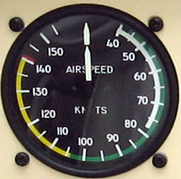 Air Speed Indicator. Measured in knots (KIAS).
The mechanism is a bellows fed by dynamic pressure from a forward-facing pitot tube, inside a
sealed aneroid chamber fed from the static vent.
Air Speed Indicator. Measured in knots (KIAS).
The mechanism is a bellows fed by dynamic pressure from a forward-facing pitot tube, inside a
sealed aneroid chamber fed from the static vent.
 The green arc shows normal operating range (up to VNO).
The white arc shows the flap operating range (the maximum speed at which flaps can be extended is VFE).
The red line shows the 'never exceed speed' (VNE)
The green arc shows normal operating range (up to VNO).
The white arc shows the flap operating range (the maximum speed at which flaps can be extended is VFE).
The red line shows the 'never exceed speed' (VNE)
|
| ATC | Air Traffic Control, AKA "The Tower". Eg Camden Tower is 120.1MHz; Camden Ground 129.1MHz; Sydney Radar is 124.55. |
| ATIS | Automatic Terminal Information Service - Recorded weather and aerodrome information, updated by tower staff throughout the day. At Camden the ATIS frequency is 125.1MHz. |
| AWIS | Automatic Weather Information Service - Recorded weather information by phone, updated throughout the day. At Camden the AWIS number is 02 4655 9248. |
| AWS | Automatic Weather Station. |
| BAK | Basic Aircraft Knowledge. A multiple-choice theory test that has to be passed before the student pilot can sit the GFPT flight test. Colloquially, Bob Tait's book covering the material tested in the BAK test. |
| BEW | Basic Empty Weight. |
| BRoC | Best Rate of Climb (VY). 60 knots in the Citabria, but we use 70 in practice. 76 knots in the PA-28 Warrior. |
| BUMFISH | Downwind checks to ensure the aircraft is in a fit state to land:
Brakes OFF (apply them briefly, then heels back on the floor)
See lesson 9.
Undercarriage DOWN (or, on a Citabria, wheels still attached to the airframe) Mixture - FULL RICH Fuel - ON (including the electric fuel pump in aircraft such as the Warrior) Instruments/Indications - NORMAL (especially oil temperature and pressure) Switches - ON (ie both magnetos) Hatches and harness -SECURE |
| CASA | Civil Aviation Safety Authority. The Australian Government body responsible for the safety of civil aviation, including aircraft registration, licencing of pilots and implementation of a safe National Airspace System (NAS). See CASA's web site for more information. |
| CAVOK | Cloud And Visibility OK in a weather report or forecast. Pronounced CAV-O-KAY. |
| CCHAT |
Procedure for making changes to the power setting:
Change
See lesson 3 - Straight and Level Flight and lesson 5 - Climbing and Descending.
Check Hold Adjust Trim |
| CFIT | Controlled Flight Into Terrain. You do not want to do this, but it seems to happen with depressing regularity, often at night or in cloud. |
| CFMOST | Checks following engine failure:
Carby heat HOT
See lesson 27 - Practice Forced Landings.
Fuel ON, and fuel in tanks (check gauges) Mixture - FULL RICH Oil temperature and pressure in the green (if in the red, there's not much point trying to restart the engine) Switches - ON (try each magneto in turn) Throttle - through the range and back to 1/3 (so you can tell if it restarts, but not so much as to cause problems if it suddenly restarts on short final) |
| CG | Centre of Gravity. |
| CTA | ConTrolled Area, usually around an airport. |
| CTAF | Common Traffic Advisory Frequency. The radio frequency used to make position broadcasts at non-towered aerodromes. Some aerodromes have their own frequency. For example, Camden's is, unsurprisingly, the same as the Tower: 120.1MHz. Other (generally smaller) airfields share the same frequency - 126.7MHz. |
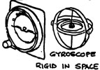
| DG | Directional Gyro. Another name for the DI. Also known as a Magnetic Compass. |
| DI | 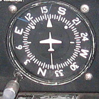 Directional Indicator. Another name for the DG. Also known as a Gyrocompass. Unlike a magnetic compass, it remains steady and unaffected by acceleration or turning errors. However, also unlike the compass, it has no way of actively seeking north or any other direction, so it needs to be aligned with the compass before take-off and every 15 minutes during a flight. That's what the knob at bottom left is for. Directional Indicator. Another name for the DG. Also known as a Gyrocompass. Unlike a magnetic compass, it remains steady and unaffected by acceleration or turning errors. However, also unlike the compass, it has no way of actively seeking north or any other direction, so it needs to be aligned with the compass before take-off and every 15 minutes during a flight. That's what the knob at bottom left is for.Like the AI, it's powered by the aircraft's vacuum system. |
| DME | Distance Measuring Equipment. Radio equipment used to display an aircraft's distance from a ground station. DME refers to both the ground-based and aircraft-mounted components of the system. |
| EFATO | Engine Failure After Take Off. This rarely happens, but when it does you need to be ready, and make the right decision, because it could be your last. In the Citabria, adopting a gliding attitude at 60kts is a good first step; further action depends largely on your height above the ground, but a steep turn is probably going to be lethal. It was lesson 19 before we got round to this drill. |
| ERSA | En Route Supplement Australia. A bit of light reading for bedtime that contains information on all Australian Aerodromes and much else besides. Pilots are expected to keep a current copy in the aircraft. |
| FAI | Flight Attitude Indicator. See Attitude Indicator. |
| FIS | Flight Information Service, otherwise known as Flightwatch. |
| GA | General Aviation (ie small planes, private pilots). |
| GAAP | General Aviation Aerodrome Procedures. The business of operating from an aerodrome under Air Traffic Control. It covers arrival and departures, altitudes, restrictions and radio procedures. |
| GFPT | General Flying Proficiency Test. An intermediate stage to a PPL. Allows a pilot to fly as pilot in command in the student pilot training area (subject to approval by an instructor), and to carry passengers. See CASA stages for more information. |
| GNSS | Global Navigation Satellite System. Generic term covering GPS and the equivalent Russian system - GLO-NASS. |
| GPS | Global Positioning System. The US version of GNSS. Fast becoming a commodity for everying from mountain biking to aviation. |
| HASELL |
Pre-aerobatic checks (before steep turns, stalls and the like):
Height (Must recover from manouevres by 3000 feet AGL. 4500 feet is normal.)
Introduced in lesson 7 - Stalling.
Revised in lesson 28 - Advanced turning.
Airframe (clean, ie flaps up) Security (harness, no loose objects) Engine (instruments in green) Location (not over a heavily built-up area) Lookout (minimum 180° and preferably a 360° turn) |
| HF | High Frequency. The (freq?) radio band used for long-distance communication in remote areas. In the outback, HF comes into its own as it follows the earth's curvature so has a longer range. |
| HSHS |
Work cycle on downwind leg of a circuit:
Heading
Heading is towards your chosen reference point, speed is 90-95kt in the Citabria, height is usually 1000 feet above ground level (which translates to 1300ft AMSL at Camden, which is at an elevation of 230 ft) and spacing is the distance on the runway, measured by lining up part of the wing (eg the jury strut) with the centreline of the runway. See lesson 9.
Speed Height Spacing |
| hPa | hectoPascals. SI standard unit of pressure. Conveniently, the same as millibars (mb). |
| IFR | Instrument Flight Rules. The rules and regulations covering the use of instruments, eg when flying in cloud or at night. Not "I Fly by Road"... |
| IMC | Instrument Meteorological Conditions. Weather conditions requiring flight by IFR. |
| ISA | International Standard Atmosphere. Assumes a pressure of 1013.25 hPa and a temperature of 15°C at sea-level. As you go up the pressure is assumed to decrease at 1 hPa per 30 feet, and the temperature at 2°C per 1000 feet. |
| KIAS | Knots Indicated Airspeed. Often abbreviated to 'kt' or 'kts'. |
| LAME | Licensed Aircraft Maintenance Engineer. |
| LF | Low Frequency. The 30-300kHz radio band, used by navigational beacons and public broadcasters. |
| MAUW | Maximum All-Up Weight. |
| MBZ | Mandatory Broadcast Zone. Now superseded by CTAF(R). An area where you are not allowed to operate unless carrying and using a radio. |
| METAR | Meteorological Aviation Report (I'm guessing here). Weather report for a particular location. |
| MF | Medium Frequency. The 300-3000kHz radio band, used by navigational beacons and public broadcasters. |
| MR | Maintenance Release. A document signed by a LAME basically indicating that the aircraft is safe to fly. It records the type, registration, date of and engine hours till the next service (in a training aircraft the hours will likely trigger the service before the date), and any required maintenance items. It's one of the three documents that must legally be carried on a flight, the other two being the pilot's licence (and medical) and current charts relevant for the flight. |
| MTOW | Maximum Take Off Weight. |
| NAS | National Airspace System. The rules and regulations to ensure that aircraft can share the air without bumping into the ground or each other. See CASA's website. Dick Smith's website is also relevant (if controversial). |
| NDB | Non Directional Beacon. A source of radio signals that can be identified and homed onto by an ADF. NDBs operate in either the low frequency (30-300kHz) or medium frequency (300-3000kHz) bands. Typical frequencies are between 200 and 430kHz. Camden is 281kHz. |
| NDV | Non Directional Visibility. In a TAF, means that visibility has been measured in a single direction only. See TAF example in lesson 6. |
| NM | Nautical Mile. Unit of distance used in aviation. One nautical mile is a second(?) of longitude at the equator. 1nm = 1.15 statute miles or 1.85 kilometres. |
| ONUS |
Effect of turning on a magnetic compass:
Overrun
This effect means that when you're turning towards north, you need to continue around 15° past your intended heading, and when turning south, you should roll out 15° before your intended heading.North Underrun South Introduced in lesson 31 - Basic Instrument Flight 1. See also: SAND. |
| PAST |
Procedure for entering a climb or descent, or levelling out after a descent.
Power
Introduced in lesson 4 - Climbing and Descending.
Attitude Speed Trim |
| P-factor |
Propellor factor. In a tailwheel aircraft, when the tail is down at the start of the take-off roll,
the angle of attack of the right propeller blade is greater than the left (for clockwise rotation). This contributes
to the tendency of the aircraft to head left, but only until the tail is raised. With the tail level and the
thrustline straight ahead, the p-factor disappears. See lesson 9 - Circuits |
| PFL | Practice Forced Landing. |
| Piano Keys | White longitudinal stripes on the runway, marking the beginning of the landing area. It's normally bad form to put the aircraft on the ground before you reach these markings (although forgiveable in certain situations, eg real or simulated engine failure). |
| PIC | Pilot In Command. Where you're in charge of the aircraft, practically and legally. A student's flying hours are divided into Dual and in Command. |
| POH | Pilot's Operating Handbook. The bible on each aircraft you fly, wherein you will find a whole load of stuff specific to this aircraft, like stall speeds, loading charts, performance graphs and procedures for normal operation and emergencies. These must be memorised and followed. |
| PPL | Private Pilot Licence. Allows the holder to commit aviation anywhere in Australia and (presumably with further paperwork, check flights etc) the world.  |
| QNH | Question Nil Height. Pressure at sea-level at this location, measured in hectoPascals (hPa). If all aircraft in a particular area set their altimeters to read the same QNH, then their relative heights will be accurate. This is essential for vertical separation and therefore safety. The 'Q' codes originated in World War Two (or possibly WW1) when radio operators used morse code so brevity was a virtue. Actually, it still is. |
| Rate-one turn | 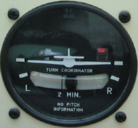 In a rate-one
turn the aircraft changes its heading at 3° per second. Therefore a 180° turn will take one minute and a
360° turn will take two minutes. The turn indicator has markings for a (correctly balanced) rate 1 turn and
shows '2 min' as a reminder of how long it takes. In a rate-one
turn the aircraft changes its heading at 3° per second. Therefore a 180° turn will take one minute and a
360° turn will take two minutes. The turn indicator has markings for a (correctly balanced) rate 1 turn and
shows '2 min' as a reminder of how long it takes.To calculate the bank angle for a rate one turn, divide airspeed by 10 and add half the answer. For example: At 80 knots, the bank angle is 12°. At 100 knots, it's 15°. At 120 knots, 18°. You can also calculate your turn radius if you hold a constant rate. At 100 knots, the circumference of the circle flown is 3.33nm. Dividing by pi gives you a diameter of 1nm. This sort of calculation is important in mountain flying. An accurate rate one turn is an important part of instrument flying. |
| Readability scale |
The readability scale (for radio transmissions) is: 1. Unreadable 2. Readable now and then 3. Readable but with difficulty 4. Readable 5. Perfectly readable |
| ROARS |
After engine start:
RPM - set to 1000
Before engine shutdown:Oil - temperature and pressure in the green (within 20 seconds) Amps - positive, indicating the alternator is working Radio - on, switched to ATIS - listen to weather, check runway in use and set QNH on the altimeter Strobes on.
RPM - 1000
First encountered in lesson 5.
Oil - pressure and temperature in the green Amps - slightly positive Radio - off Switches - check magnetos - left off and on; look for the rpm drop, then right. Finally turn all switches off and pull mixture to full lean to shutdown |
| RoD | Rate of Descent, measured in feet per minute. |
| RPM | Revolutions Per Minute. Engine speed. For example the Citabria should be taxiied at 1000 RPM (or the plugs are liable to oil up) and normal cruise is 2200 RPM. |
| SAND |
Effect of acceleration and deceleration on a magnetic compass:
South
In other words, when you accelerate, the compass will swing towards the south, and when you decelerate, it will swing towards the north. Not sure if this is the same in the northern hemisphere.Acceleration North Deceleration Demonstrated during lesson 31 - Basic Instrument Flight 1. See also: ONUS. |
| S&L | Straight & Level. |
| SMC | Surface Movement Control. Colloquially, 'Ground'. At Camden the Ground frequency is 121.9MHz, but in practice it is not used. When the Tower is operating, your first contact is with the tower at the hold point, and when the tower is not operating, you make a taxiing call on the CTAF frequency (120.1, same as the Tower). |
| Special VFR |
By day, when VMC does not exist, ATC
may issue, at pilot request, a Special VFR clearance for flight in
the Control Zone, or in a controlled area adjacent to the zone, for the purpose of entering or leaving the zone, provided:
|
| SPL | Student Pilot Licence. You can start training without this licence, but you need it to fly solo. |
| TAF | Terminal Area Forecast. The most detailed weather forecast avaialble, produced for individual aerodromes worldwide. See example in lesson 6. |
| TBO | Time Between Overhauls. Usually of engines. |
| TCAS | Traffic Collision Avoidance System. A black box on larger aircraft which detects transponder codes of nearby aircraft and warns of potential collisions. |
| TIF | Trial Instructional Flight. An introductory lesson during which you decide whether flying's for you, and your instructor gets a feel for your aptitude and suitability. |
| TOSS | Take Off Safety Speed. The speed you want to reach after take-off before you commence the climb. For the Citabria it's 52 knots. |
| VA | Manoeuvring speed (no full control deflections above this speed or you run the risk of structural damage). |
| VFR | Visual Flight Rules. Flying and navigating using the Mk I eyeball. The only way I'll be flying unless I win Lotto. |
| VFE | Maximum speed with flap extended. |
| VHF | Very High Frequency. The 30-300MHz radio band used for most air to air and air to ground conversations, at least in populated areas. Other radio bands include HF. |
| VMC |
Visual Meteorological Conditions.
Weather conditions suitable for flight by VFR. Class D controlled airspace: Visibility 5000m; 1500m horizontal and 1000ft vertical distance from cloud. ATC may permit operations in weather conditions that do not meet these criteria (Special VFR) Class G non-controlled airspace: At or below 3000ft AMSL or 1000ft AGL, whichever is higher: visibility 5000m; clear of cloud and in sight of ground or water. Below 10,000ft AMSL: visibility 5000m; 1500m horizontal and 1000ft vertical distance from cloud. Above 10,000ft AMSL: visibility 8000m; 1500m horizontal and 1000ft vertical distance from cloud. |
| VNE | Never exceed speed (or you run the risk of structural damage). |
| VNO | Normal operating speed. |
| VOR | VHF Omnidirectional Range. Ground equipment transmitting a coded signal at each bearing from 1° to 360°, and the aircraft-mounted receiver. An aircraft fitted with VOR can determine which radial (ie bearing) it is on with respect to the ground station, how much it is off track and whether the bearing is from or to the ground station. |
| VS0 | Stall speed in landing configuration (full flap). |
| VS1 | Stall speed in clean configuration (no flap) at MAUW. |
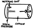
| VSI |
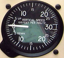 Vertical Speed Indicator. Shows rate of climb or descent in hundreds
of feet per minute. The source is static pressure.
Vertical Speed Indicator. Shows rate of climb or descent in hundreds
of feet per minute. The source is static pressure.
 The Citabria's initial climb is well over 1000 feet/minute. The usual rate of descent is more gentle - 500 feet/minute.
This is chosen as much for passenger comfort as for performance and handling reasons.
The Citabria's initial climb is well over 1000 feet/minute. The usual rate of descent is more gentle - 500 feet/minute.
This is chosen as much for passenger comfort as for performance and handling reasons.
|
| VTC |
Visual Terminal Chart. A large-scale chart covering the area around a major airport. Note that the yellow areas mark the shape of the lit areas at night.

|
| VX | Speed for best angle of climb. |
| VY | Speed for best rate of climb (faster than VX because at a shallower angle). |
| WOSSSSSET |
Factors to evaluate when identifying a suitable emergency landing spot:
Wind (smoke, water, flags, ATIS)
Introduced in lesson 27 - Practice forced landings.
Obstacles (power lines, fences, trees, high ground) Size (at least 500m long. Width? ) Shape (try to find a straight runway shape) Surface (hard and smooth. Look for ruts and holes. Ploughed (brown) is no good) Slope (preferably land uphill. Use creeks and dams to get slope) Sun (try not to land into a setting sun) Elevation (to estimate high key/low key altitudes. Camden is 230'; The Oaks is 900') Terrain (surrounding terrain may change the approach. Watch for wind shear) |
Other links: